Download Image
5.27 MB

ID # 254
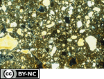
Porphyric related distribution patternFrom the Soil Micromorphology Slide Collection
STEM Standard addressed: ESS2E - Biogeology
Appropriate Grade Level(s)
- College-level
- Classroom Lectures
- Laboratory Activities
- Soil Microbiology
Data for the horizon
Horizon sampled: 2Bt1 Depth sampled: 109-137 cm
Physical and chemical description: Coarse fragments = 1%, sand = 23%, silt = 49%, clay =
28%, pH = 5.8, QC = 0.13%, base sat. = 82%
Macromorphological description of horizon: 1OYR4/6 silty clay loam; common coarse distinct 1OYR5/8 and 1OYR6/2 mottles; weak medium prismatic parting to moderate medium subangular blocky structure; firm; 7% brittle in brown areas.
Micromorphological description of horizon: Porphyric s-matrix with brown (80%) and gray (20%) zones;common macro and vughs and macro channels; occasional, compound, strongly and continuously oriented ferriargillans (30-120 µm) along vughs and channels; occasional, simple, moderately striated, extremely birefringent argillans (20-50 µm) along channels and vughs; occasional, extremely birefringent quasiargillans (30 µm) occur parrallel or inclined to channels; occasional quasigoethans (50-150 µm) occur in the vertical section parallel or inclined to channels.
Data for thin section
Preparation of sample: Air dry
Impregnating medium: Epoxy
Thickness of section: 30 µm
Size of section: 50 x 75 mm
Orientation of section: Horizontal
Soil classification
U.S.: Fine-silty, mixed, mesic Typic Glossaqualf
Environment :
Elevation: 294 m
Physiographic position: Ground moraine Topography: Nearly level; 1/2% slope
Parent material: Wisconsinan loess over lllinoian glacial till
Vegetation: Mixed hardwood forest (elm-ash swamp forest)
Method
Data for 35-mm Slide Frame length: 3325 µm
Light mode: Circularly polarized
Note: In the terminology of Bullock et al. (1985), this RDP is single- and double-spaced porphyric.
Light mode: Circularly polarized
Note: In the terminology of Bullock et al. (1985), this RDP is single- and double-spaced porphyric.
References
Ransom, M. D., N. E. Smeck, and J. M. Bigham. 1987a. Stratigraphy and genesis of polygenetic soils on the lllinoian till plain of southwestern Ohio. Soil Sci. Soc. Am. J. 51:135-141.
Ransom, M. D., N. E. Smeck, and J. M. Bigham. 1987b. Micromorphology of seasonally wet soils on the lllinoian till plain, U.S.A. Geoderma 40:83-99.
Source - M. Ransom
Slide RDP9. Soil Science Society of America, 1993. A Reference Slide Collection for Soil Micromorphology. SSSA, Madison, WI.
Ransom, M. D., N. E. Smeck, and J. M. Bigham. 1987b. Micromorphology of seasonally wet soils on the lllinoian till plain, U.S.A. Geoderma 40:83-99.
Source - M. Ransom
Slide RDP9. Soil Science Society of America, 1993. A Reference Slide Collection for Soil Micromorphology. SSSA, Madison, WI.
Peer Review: Yes
Credit this item to: SSSAMedia Date: 1993-01-01
Provided By: (SSSA) Soil Science Society of America
Latitude: 38.9092089
Longitude: -83.84730150000001
Author(s)/Creator(s)
-
* Soil Science Society of America
SSSA
Submitted By: (SSSA) Soil Science Society of America
Keywords
- Related Distribution Patterns
- 2Bt1 horizon
- micromorphology
- Porphyric
Comments
Please login to submit a comment.
Log In to your account
Already a member, certified, or existing customer?*
* Cookies must be accepted to log in.
Not sure if you have an account?
Check Your Email
Join Us!
Connect with members and access the information you need.
Learn more.
Ready to Join?
If you have an account, login on the left. Not sure if you have an account or need to create one? Check your email with the link above. We look forward to welcoming you.