Download Image
379.45 KB

ID # 252
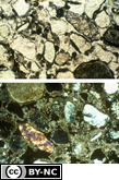
Gefuric related distribution patternFrom the Soil Micromorphology Slide Collection
STEM Standard addressed: ESS2E - Biogeology
Appropriate Grade Level(s)
- College-level
- Classroom Lectures
- Laboratory Activities
- Soil Microbiology
Data for the horizon Horizon sampled: Bk2 Depth sampled: 60-85 cm
Soil climate data: MA precipitation = 8 cm, aridic moisture regime; MAT = 23°C, hyperthermic temp. regime
Physical and chemical description: Clay = 7.7%, silt = 9.5%, sand = 82.8%, coarse fraction
3%, QC = 0.07%, bulk density = 1.55 Mg m-3 CaC03 = 17%, pH = 8.5
Clay mineralogy: Palygorskite moderate; montmorillonite, kaolinite, calcite in trace amounts Macromorphological description of horizon: Light yellowish brown (1OYR 6/4) sandy loam,
yellowish brown (1OYR 5/4) moist; massive; slightly hard, very friable, slightly sticky and nonplastic; common medium lime nodules; violently effervescent
Micromorphological description of horizon: Gefuric related distribution pattern (Bullock et al., 1985); crystic plasmic fabric (Brewer, 1976)
Data for thin section:
Preparation of sample: Air dry
Thickness of section: 30 µm
Size of section: 25x40 mm
Soil Classification
U.S.: Sandy, mixed, hyperthermic Typic Calciorthid
Elevation: 162 m
Physiographic position: Stream terrace Topography and hill slope position: Dune Parent Material: Eolian sand
Vegetation: Creosotebush, turkshead, big galleta
Method
Data for 35-mm slide
Frame length: 1 mm
Light mode: Plane polarized (RDP5); cross polarized (RDP6)
Frame length: 1 mm
Light mode: Plane polarized (RDP5); cross polarized (RDP6)
References
Herriman, R. C. and D. M. Hendricks. 1984. Geomorphic Surfaces and Soils, Colorado River Area, Arizona. Guidebook, Soil-Geomorphology Field Conference, Soil Science Society of America, 76th Annual Meeting, Las Vegas, Nevada, November 30, 1984. USDA-SCS in Cooperation with AES-U of A.
Source - W.D. Nettleton
Slides RDP5 and RDP6. Soil Science Society of America, 1993. A Reference Slide Collection for Soil Micromorphology. SSSA, Madison, WI.
Source - W.D. Nettleton
Slides RDP5 and RDP6. Soil Science Society of America, 1993. A Reference Slide Collection for Soil Micromorphology. SSSA, Madison, WI.
Peer Review: Yes
Credit this item to: SSSAMedia Date: 1993-01-01
Provided By: (SSSA) Soil Science Society of America
Latitude: 32.6926512
Longitude: -114.62769159999999
Author(s)/Creator(s)
-
* Soil Science Society of America
SSSA
Submitted By: (SSSA) Soil Science Society of America
Keywords
- Related Distribution Patterns
- Bk2 horizon
- micromorphology
- Gefuric
Comments
Please login to submit a comment.
Log In to your account
Already a member, certified, or existing customer?*
* Cookies must be accepted to log in.
Not sure if you have an account?
Check Your Email
Join Us!
Connect with members and access the information you need.
Learn more.
Ready to Join?
If you have an account, login on the left. Not sure if you have an account or need to create one? Check your email with the link above. We look forward to welcoming you.