Download Image
5.16 MB

ID # 234
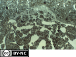
Silt coating/infillingFrom the Soil Micromorphology Slide Collection
STEM Standard addressed: ESS2E - Biogeology
Appropriate Grade Level(s)
- College-level
- Classroom Lectures
- Laboratory Activities
- Soil Microbiology
Data for the horizon Horizon sampled: 3Ab1
Depth sampled: 174-181 cm below the modern land surface; interpreted to be the surface horizon of the buried paleosol
Physical and chemical data available: Sand = 5%, silt = 66%, clay = 29%; QC = 1.8 g kg- 1 ; pH
= 7.7
Macromorphological description of horizon: 1OYR 4/3 silt loam; moderate fine subangular blocky structure; common, thin, discontinuous 1OYR 7/2 silt coatings; common fecal pellets
Micromorphological description of horizon: Dominantly granular microstructure; single-spaced embedded-grain related distribution pattern; stipple-speckled pattern; porosity dominated by irregularly shaped, compound packing pores of varying size and by channels 150-800 µm in diameter; silt coatings (3-4% of section) and microlaminated clay coatings appear to have been derived from overlying loess; few nodules of micritic calcite; fecal pellets (2-5%, probably earthworm) range from 275 µm to about 1 mm in diameter; moderately to strongly impregnative Fe oxide nodules (2-3%). rounded and irregularly shaped, ranging from 10 to about 900 µm in diameter.
Data for thin section
Preparation of sample: Air dry
Impregnating medium: Polyester resin
Thickness of section: 30 µm
Orientation of section: Vertical
Soil Classification
U.S.: Paleosol was probably an Argiudoll when at the land surface
Legal description: E 1/2, SE 1/4, NE 1/4, S20,T76N, R40W Physiographic position: Upland
Topography and hill slope position: Summit of a 9% hillslope Parent material: Loess
Soil climatic data and/or soil water balance: Well-drained position on modern land surface; likely to be similar on paleosurface
Vegetation: Probably tallgrass prairie when paleosol was at the land surface
Method
Data for 35-mm slide
Frame length: 7 mm
Light mode: Plane polarized
Frame length: 7 mm
Light mode: Plane polarized
References
Thompson M. L., and T. A. Soukup. 1990. Morphological characterization of a suite of buried paleosols in Pottawattamie County, Iowa. p. ln E. A. Bettis (ed.) Midwest Friends of the Pleistocene 37th Field Conference, May 12-13, 1990. Iowa Geol. Surv. Bur.
Source - M. L. Thompson
Slide CT48. Soil Science Society of America, 1993. A Reference Slide Collection for Soil Micromorphology. SSSA, Madison, WI.
Source - M. L. Thompson
Slide CT48. Soil Science Society of America, 1993. A Reference Slide Collection for Soil Micromorphology. SSSA, Madison, WI.
Peer Review: Yes
Credit this item to: SSSAMedia Date: 1993-01-01
Provided By: (SSSA) Soil Science Society of America
Latitude: 41.3911501
Longitude: -95.47778110000002
Author(s)/Creator(s)
-
* Soil Science Society of America
SSSA
Submitted By: (SSSA) Soil Science Society of America
Keywords
- Coatings
- 3Ab1 horizon
- micromorphology
- Silt coating/infilling
Comments
Please login to submit a comment.
Log In to your account
Already a member, certified, or existing customer?*
* Cookies must be accepted to log in.
Not sure if you have an account?
Check Your Email
Join Us!
Connect with members and access the information you need.
Learn more.
Ready to Join?
If you have an account, login on the left. Not sure if you have an account or need to create one? Check your email with the link above. We look forward to welcoming you.